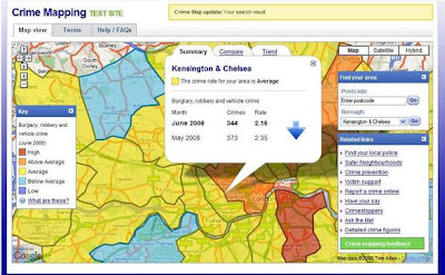
London’s Metropolitan Police have launched a trial website service, thanks to Boris Johnson, that aims to highlight the city’s trouble areas. You can search by postcode to narrow down an area or view the map in its entirety to see how the different boroughs compare on crime.
The mapping service is only in beta at the moment but I feel it does need to include more data to paint an accurate picture. The color-coded zones are based on data from burglary, robbery and vehicle theft, but for this to assist Londoners in a meaningful way, it should address the types of crimes we are most concerned about.
The mapping data should include stabbings, shootings and violent crimes, something I’d imagine would be more relevant given the constant reports of knife violence in the media.
Living in London myself, I thought I’d take this SimCity-esque service for a run and check out my area (sadly, you can’t add more police stations). I was expecting the worst and found out I was in an average band (could have fooled me), and that an area I have been considering moving to, partly because it seemed safer, is in a ‘high’ red band. Go figure! Is it me? Or is it them? Is it helpful? Or is it misleading? Who knows how accurate the data is.
Richmond is low, yet posh Paddington is above average. Don’t ask me why. Probably all their high-end cars getting pinched. Heathrow seems okay, think I’ll go sleep on a runway. I’ll be safe there, right?
Sources:
Met Police Maps
Via: Gizmodo and TechRadar
